
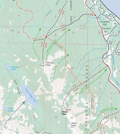


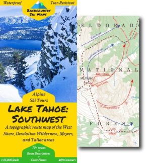
This comprehensive topographical route map makes it easy to find new ski lines in the Tahoe backcountry. Covering the area from Rubicon Peak down to Ralston Peak from North to South, and from Mt. Price to Flagpole Peak from East to West (see below above for a zoomable map with the full area of coverage), it includes some of the raddest descents around.
Includes ski routes on:
- Mt. Tallac
- Jake’s Peak
- Pyramid Peak
- Dick’s Peak
- Echo Peak
- Angora Peak
- and many more!
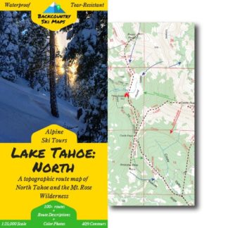
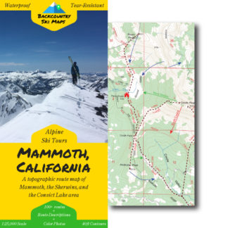
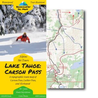
Route information, including suggested approaches and descents, is marked on a large scale 1:25,000 map to get you home safely. The map is accompanied on the back by a self-contained field-guide which shows photos and gives detailed descriptions of some of the most worthy descents – the perfect way to get in the know about backcountry skiing in Tahoe.
Descents of all varieties – from killer couloirs to wide open glades – are all covered, so there is something for everyone from the hardened veteran to the beginner tourer.
Features:
- 70+ descents ranging from classics to rarely-skied lines
- Suggested ascent routes to get you up the hill as efficiently as possible
- Field-guide to the best descents complete with color photos
- Waterproof, tear-resistant so you never have to worry about damaging your map
- Fits in your pocket – the map folds down to 4.25″ x 9″ (21.25″ x 27″ when open)
- Highly detailed with 40ft contour lines
- Easily readable with a 1:25,000 scale
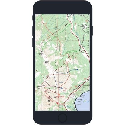
** Please note that digital maps do NOT include the color photos or route descriptions included in the paper maps. You’ll need to download the Avenza app to use the digital versions of our Backcountry Ski Maps – they are not viewable on a PC or elsewhere outside of the Avenza app. **
Area of Coverage
Anonymous –
Beast of a map. Thank you for a fantastical product that doesn’t disappoint. Can’t hardly damage this map, I’ve tried.
David Conrad –
Honestly I’d love to see the addition of low-angle Nordic backcountry routes for the whole family to enjoy 🙂
Brian Thom –
The hard copies are nice. And the digital ones work easily as well. My expectation was that I’d be able to start breaking into some new zones that I know nothing about, and then learn more with experience. The maps are prefect for that. Worth every penny.
saul –
This looks excellent but I have yet to use it. Hopefully in the spring when/if the weather calms down a little.
Suzanne –
Great map! I’m glad someone is finally putting this together. Thanks for making it available to Avenza too. A general comment for all the maps… I would like to see more place names on the map. Ridges, mountains, descents. Gracias!!!!
Katherine Hill –
I ordered a digital copy. Not a copy to use in an app; I wanted a PDF digital version for reference for work. Totally wasted my money
Chris Noe –
I would give 5 stars if they were printed on heavier paper like a Harrison map
Anonymous –
My first backcountry map. Very impressed on its quality!!
Justin Barham –
Routes/approach could be more obvious
Eli L. –
Use the digital version all the time and keep a physical copy as backup. Absolutely priceless.
Anonymous –
Many of the best are not covered here
Siobhan –
Super helpful. Has given me confidence to check out areas I have not been to in the past. The ability to plot my route in advance, and then track my location live on my planned route is fantastic and saves me time and energy because I don’t get off route. I’ve purchased for maps three areas.
Ian Mclens –
Easy to use and accurate
William H. –
Great map, nice to have a hard copy
Ralf VonSosen –
Maps are excellent and the advice on tours super helpful.
Anonymous –
Very nice topo map showing popular bc ski tours. I have to say THANK YOU for utilizing both sides of the map. I can’t tell you how frustrating it is to get a map that is only printed on one side and wastes the other (Harrison maps *cough cough*). The one thing that’s holding me back from giving 5 stars is the lack of parking info. Parking to access our public lands in the Tahoe basin is incredibly limited, in the winter it is near impossible. Maybe the real solution is more relevant to local government, but they only seem to work for tourists. Some legitimate parking tips would make this 5 stars.
Declan O’Connell –
Great papermaps and the smartphone routes are very accurate.
Erin S. –
Super helpful
Anonymous –
Very helpful! Affordable and thank you for going out of the way to make these great, interactive maps!
Allen I. –
These maps are one of a kind and an amazing resource. I highly recommend them.
David S. –
Great map
John C. –
Looks good, can’t wait to try.
Charlie –
Not a fan how it doesn’t scale with the apps zooming. It’s a set number of pixels and detail and contour line separation, which is perfect for a map, when you have the whole thing in front of you, but not ideal when you have to zoom and scan to particular areas. Also it would be GREAT if your maps were compatable with Garmin or Gaia (preferably Garmin) so we could download them as an overlay on the watch or inreach and follow them from there. Currently, the one app that is available is really not a very powerful app and doesn’t have a lot of transferrable features to other apps (Garmin Basecamp, Strava, etc.). Would be most useful if the map either could overlay on these more popular apps, or if you could export gtx files of the routes after you purchase them.
This is a lot of personal preference, if I’m the only one, it’s not as big of a deal, but I do believe there’s a big opportunity here to expand/improve to make these maps even better than they are.
Anonymous –
Thanks for the suggested routes! Some write ups of what to look for would be great!
evanderkloot –
Sure thing! I’m guessing that you got only a digital download. If you’re looking for write ups, our physical paper maps include guide text and photos of the best lines too!
Anonymous –
While going on some of these tours, this helped me noticed that there were many more lines out there!
jamin horn –
Great maps, they pack a lot of useful information into a small space. Perfect to throw in the pack and get out with. Would definitely recommend to anyone looking to get out into the backcountry.
Anonymous –
Great resource for backcountry skiing. Easy to read and navigate.
Anonymous –
useful and informative
Linda D. –
Great map…just what I was looking for!
Anonymous –
I really like the slope shading on digital map. would like a little more detail on routes
SEAN CROM –
The maps give the basic information. Some comments about parking might be useful
Backcountry Ski Maps –
Thanks for the feedback Sean. There is a section on the back of the map titled “Access” where we comment on the parking situation around the lake. As is mentioned there, the maps don’t explicitly mark the starting points of the tours as parking spots since access around the lake is changing so quickly (i.e. new access for the Lake Run this season). That being said, the marked starting points are (as of the time of publication) the proper parking locations for the routes on the map. Check out https://tahoebackcountryalliance.org/ for more information on how we can all contribute to improving the parking situation around the lake!
Anonymous –
1. Slope shading in electronic maps is very good and useful for route planning.
2. Coverage between maps is incomplete. I bought Lake Tahoe North and Lake Tahoe South expecting map coverage for a ski tour starting in the North and ending in the South. There is a big gap that is not mapped.
3. Route planning is tedious in the app. Option to snap-to marked routes would be helpful.
4. Exporting and importing data could be more user-friendly.
5. Routes are limited to the most popular routes. I bought the maps for route planning on less well-known routes.
Wendy S. –
Killer map,and we already went out and got mt Ralston for a nice day adventure.looking for a week at lake aloha. Thank you so much!!!
Anonymous –
Love it. Life saver in the back country.
Mark Warren –
Very helpful
Tim M. –
Great map, super useful. Thank you!
Ken G. –
Other than the west shore, I don’t know this area as well as the north side of the lake. But this map looks just as comprehensive as the north shore one. I’ll have to make a trip down to the south side soon 🙂
Patrick R –
Haven’t had a chance to use it yet (it’s September after all!) but the map looks amazing. So many lines to go explore this coming winter!
Carmen Casey –
I purchased the Lake Tahoe: Southwest digital download map to snowshoe, rather than skiing, and it worked perfectly! I always wanted to do Mt. Tallac in the winter and the only way to do it was via the ski route. It was easy to follow the track and it made our trip a success. I definitely recommend this track and route for a successful trip to Tallac.
Nick –
Map, routes, descriptions, etc are all well laid out; it is sturdy and easy to use. So far I have skied one of the map’s routes off Tallac. The map is very accurate. Seeing and reading about all the other routes makes you want to spend a month in Tahoe, although some of the descents are sadly out of my league. Having a hard (back-up) copy is essential IMHO in case conditions go sour and all other technology fails. Very useful and strongly recommended!
Andy –
I’m really happy with this map. I stumbled on this from an online forum and was worried about the paper, all my usual topo maps fall apart in the winter. This has held up really well after a couple tours.
Peter W –
When it comes to backcountry skiing, I usually team up with a local friend who knows the terrain to ski the best POWDER descent routes but for my Tahoe trip, I didn’t have a friend to go to with; luckily I found backcountry ski maps. My goal is to maximize my time from a detailed backcountry ski map so I’m glad I bought a hard copy of Lake Tahoe: Southwest backcountry ski map which provided great info/guide to locate the best ski routes which saved me alot of time and delivered pure backcountry skiing fun. Highly recommended!
Carl H –
Great map. This saved me a lot of time. I used to have to do a ton of research and work to overlay routes onto maps. This is all I need now. It’s lightweight, tough/waterproof, and a decent scale/ratio.