
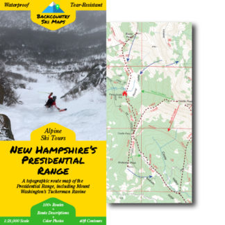
This easy-to-use map covers the best ski touring destination on the East Coast – New Hampshire’s northern Presidential Range (including Mount Washington’s world famous Tuckerman and Huntington Ravines).
Included are lines in:
- Tuckerman Ravine
- Huntington Ravine
- The Great Gulf
- The Gulf of Slides
- Jefferson Ravine
- Castle Ravine
- Oakes Gulf
- King Ravine
- Burt Ravine
- Ammonoosuc Ravine
- and more!
Route information, including suggested approaches and descents, is marked on a large scale 1:25,000 map, to help you make the most out of every day in the New Hampshire backcountry. The map is accompanied on the back by a self-contained field-guide which shows photos and gives detailed descriptions of some of the most worthy descents, making it easy to find the best trips for any conditions.
Descents of all varieties – from killer couloirs to wide open glades – are all covered, so that you can find the run that’s right for you, whether you’re a a hardened veteran or a beginner tourer.
Features:
- 100+ descents ranging from classics to rarely-skied lines
- Suggested ascent routes to get you up the hill as efficiently as possible
- Field-guide to the best descents complete with color photos
- Waterproof, tear-resistant so you never have to worry about damaging your map
- Fits in your pocket – the map folds down to 4.25″ x 9″
- Highly detailed with 40ft contour lines
- Easily readable with a 1:25,000 scale
** Please note that digital maps do NOT include the color photos or route descriptions included in the paper maps. You’ll need to download the Avenza app to use the digital versions of our Backcountry Ski Maps – they are not viewable on a PC or elsewhere outside of the Avenza app. **

Craig B. –
Great resource for skiing here in the Mount Washington valley.
Anonymous –
very well done
Thomas Van de Velde –
Errata: 49. Pony Express is missing in the decent key
evanderkloot –
Thanks for the heads up Thomas. This will be correct in the next print!
Tom B. –
Makes orienteering sooooo much easier!!!! Thanks.
Joseph Cruz Jr –
The detail is great! I can not wait to get out there!
Thomas H. –
Real happy to see the map wasn’t made of paper. I got it in the mail yesterday. So stoked! Thank you!
Anonymous –
We have not received it
James D. –
Great resource to keep in pack
Anonymous –
Love It!
Michael C. –
Great map! I love the fact that it’s printed on waterproof material. Lots of good narrative information on the back.
Ernest F. –
Great format, size, AND you can fold it back to it’s original size and shape
Michael Roman –
cant wait to use this!!
Robert Scarazzo –
Concise, easy to read, tons of info. One map. Great job thanks
paul lohnes –
Love the map and the digital download. So I preordered the maps and digital download. Well worth the money. I still have this nagging question of why most of this Backcountry mapping stuff ends up on Avenza? The lack of ability to route plan on a PC, like you do for off road MTB and gravel, is a real limitation. Possibly worse is the fact you need to fumble with an Iphone in the field, which is likely going to be frigid, windy, icy (pick your NE condition). Open source maps on a Garmin work like a charm, and you can do all your planning at home on a PC. I have one attached to my pole and a simple glance, with mittens on, is all I need to do. Avenza just seems really limiting. Maybe it’s a revenue thing….thats’ cool…but just would be nice to understand. I would really appreciate a response to this question.
evanderkloot –
Hi Paul, unfortunately GPX files and open source maps simply get shared too frequently to be a viable option for us… We’re always looking for ways to improve, so if anyone reading this has any other ideas on how we can improve the digital product, please reach out via our contact form!
Robert DeLena –
Love the level of detail even for some of the lesser known routes, but I am slightly biased because my son is on the cover!
Craig B. –
Just a fabulous resource, so happy you published this. Extremely detailed and useful. Thanks to all who made it possible.